
Geospatial data management involves collecting, storing, and sharing data. People can use geospatial data management for different operations within an organization. The geospatial data management plan should link to the organization’s values and goals. In addition, the plan should be updated as organizational priorities change.
The first step is to determine which geospatial data are most relevant to the organization. For example, an organization might have data on water supplies, which are essential for planning projects, while another data set might be useful for tracking stormwater. It’s also important to understand what each stakeholder needs. This information will inform the types of data that are necessary to meet those needs. Organizations should also avoid wasting geospatial data for side projects. Identifying the most apparent challenges and issues will help organizations get higher-ups on board with geospatial data management.
Benefits of using geospatial data management
Geospatial data management provides organizations with a powerful tool to visualize data. This information is often static but can also be real-time, like information from mobile devices and location sensors. This information can be helpful for many purposes, from planning emergency responses to predicting service disruptions.
People can use geospatial data to make informed decisions about land use and biodiversity. For example, it can help predict the effect of changes in land use and identify suitable areas for conservation. This information can also guide large-scale conservation projects. For instance, a team from the Australian National University is mapping trees using mobile scanning and combining the data with other sources.
Another advantage of geospatial data is its ability to solve problems more quickly. Organizations that have a large number of assets and are working on complex projects need to coordinate and integrate their data from different departments. Geospatial data management helps them do this more effectively, increasing efficiency and safety.
Geographic Information Systems
Geographic Information Systems (GIS) are programs that can analyze and manage spatial data. They use digital maps to create data visualizations. They are often used in forest inventories and monitoring. Geospatial data management systems can handle a lot of data formats, from raster to vector.
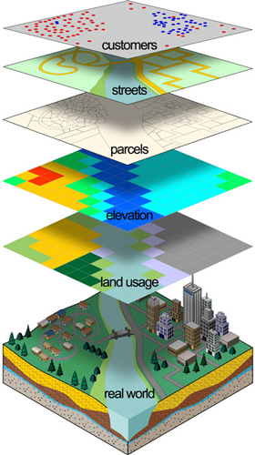
Geospatial data refers to data that is related to physical phenomena, such as roads, elevation, and trees. GIS data allows users to visualize the relationship between these objects and the surrounding areas. People can use the information retrieved from GIS for decision-making and management.
Collecting Geospatial data
Collecting Geospatial data is a process that combines different types of data from several sources. This type of data can be manually compiled or captured with sensors. Some examples of geospatial data include aerial photographs, satellite images, and cell phone GPS chips. Most geospatial data is made available in an open format, which allows for easy access and analysis by other users.
Using geospatial data is essential for various applications. For example, it can help to manage the effects of natural disasters such as hurricanes or earthquakes. People can also use it for large-scale projects, such as construction and military operations. The information can also be used by law enforcement and security personnel to map terrain, create maps of large venues, and record evidence.
Geospatial data management benefits for businesses
Using geospatial data for decision-making can benefit businesses in many ways. It can help companies better understand their customers and other stakeholders to meet their needs and goals. The ability to track geographic data will allow companies to understand trends, predict future outcomes, and act on observations.
Geospatial data can be used by businesses of all sizes and types. In some cases, it can be used to speed up deliveries and reduce costs. It can also be used to track customer information. In other instances, geospatial data can be used to analyze customer behavior and develop marketing strategies that drive revenue.
For example, consumer-goods companies can leverage geospatial data to analyze consumer buying habits. Another application for geospatial data management is in the field of environmental risk assessment. Environmental conditions, including climate change, pose a range of business risks. As a result, companies are increasingly incorporating real-time data into their geospatial data analytics platform. These organizations can also make better decisions about risk mitigation and environmental conditions.
